
District Profile
The district owes its name to King Arjun Deo's daughter Champawati. Earlier this district was a part of district Almora. In 1972 the Champawat Tahsil of Almora district was transferred to Pithoragarh. On 15th Sep, 1997 Champawat district was given an independent identity.
The district Champawat is situated between 29 degree 5 minutes and 29 degree 30 minutes in northern altitude and 79 degree 59 minutes and 80 degree 3 minutes at the center of eastern longitude. The Ram Ganga River acts as a border between Champawat and Pithoragarh in north while Jabgura and Pannar rivers in south and west respectively act as a border between Champawat, Udham Singh Nagar and Almora districts simultaneously. The long chain of mountain in southwestern region acts as a border between the district Champawat and Nainital district. It is very important in respect of defense point of view as in the east Kali river acts the international border between Nepal and India. The geographical coverage of Champawat is about 1613 sq. km. It includes four Tahsil and development blocks having 691 revenue villages.
Topography
Champawat mainly consists of mountain ranges, large valleys, uneven landscapes, breaked cliffs, rivers and rivulets. The important rivers are Ladhia, Sharda, Lohawati, Panaar. Jagbura and Ramganga. All these rivers amalgamate with Kali River at Pancheswar. Only the Sharda river which goes to Terai area flows through. On the basis of geographical distribution it can be divided in three main parts. First one, the 35 villages of Tanakpur (Purnagiri) Tehsil fall in Terai area and are important from the view point of plain and agricultural land and a warm area of an average height of 200 to 250 meter, having abundance of water and good soil. Second one, is Shivalik (mid hill) which is situated at a height of 250 to 1200 meter. It represents a sloping and uneven topographical land consisting of dense forests. Third one is hilly area having average height of 1500 mts. ( from 1200 to 2200 mts).
Climate
The climate of the district is varying from hot humid to extreme cold. Terai area is hot humid, whereas hilly regions are comparatively cold. The climatic condition of Terai and plains are almost similar, the seasonal rain is comparatively high (about 1300-1500 mm. yearly). Summer season is too hot and winters are too cold and foggy in Terai region. The climate of Shivalik is more or less same but the higher region of Himalayas experience cold climate throughout the year. In summers, Champawat district is pleasant throughout the year. But lowest temperature observed as -2 degree Celsius during the winter at the time of snow fall where as highest atmospheric temperature 33 degree Celsius during extreme summer.
Mineral Resources
Many ores, minerals, soils and rocks are available in the hills of Champawat. According to geological survey of India this region is having ample of lime, magnexide, soapstone, gypsum. Apart from these various ores and minerals are also available in this region such as ognexide, quanite, graphite etc. as per the GSI report.
Irrigation & Water Drainage
The district is rich with natural perennial rivers and rivulets. Because of Lohawati, Jagbura, Ramganga, Kali and other rivers the scarcity of water has never been felt, but due to uneven geographical condition the major portion of water drains off through small rivers and rivulets. Only about 9 percent of total land is termed as agricultural irrigated land of the region. The major portion of land is dependent on the rain water only, which has adverse effect on agricultural production. Despite plenty of resources the habitants of the area are dependent of the rain water. In the villages women usually cover a long distance for collection of drinking water.
In this district 65 percent of the area is under forest and net sown area is less than 10 percent. Agriculture is manly rainfed and about 9% of the sown area is irrigated. Small and fragmented land holding is another constrain in agriculture production.
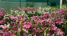
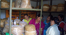
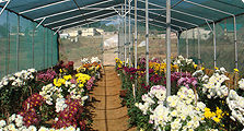
It would be obvious from the above description that the economy of the distt. is based on agriculture and to some extent on minor forest produce and vegetable production. Lack of agricultural land and resources has always been a reason for the poor economic status of the rural people. A large number of males are serving in the armed forces, semi armed forces, other government and private sector jobs outside the district. The family economy is more of less dependent on the money order system. Therefore, there is a large number of women headed households. The district is economically and socially backward with acute poverty and society ridden with outmoded traditions and even superstitions. The women suffer from all kinds of social disabilities and at the same time handling each and every responsibility of domestic and agricultural work as well as collection of fuel and fodder and in large cases drinking water from distant places.